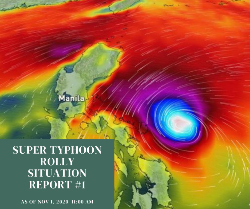
On October 28, Wednesday morning, the weather disturbance remains a tropical depression – the weakest kind of tropical cyclone according to PAGASA. TD Rolly is now 1,960 kilometers East of Central Luzon. It is slowly moves west northwest toward the PAR’s eastern boundary.
TD Rolly is now 1,960 kilometers East of Central Luzon.
PAGASA warned that the tropical depression is seen to intensify into a tropical storm in the
next 24 hours, and then into a severe tropical storm within 24 hours after that. Then, within
another 24 hours, it could already be a typhoon.
On October 29 at 5:00 PM, TD “Rolly” entered the Philippine Area of Responsibility (PAR) as a
severe tropical storm and swiftly strengthened into a typhoon at 8:00 pm. TY Rolly was last
spotted 1.280 km east of Central Luzon with maximum sustained winds of 130 kph near the
center and with a gustiness of up to 150 kph.
On October 30, at 3:00 AM, the eye of the TY Rolly was located based on available data at
1,195km East of Central Luzon with maximum sustained winds of 140 km/h near the center
and gustiness up to 170 km/h. It is moving westward at 20 km/h.
At 5:00 pm, TY Rolly intensified further as it moved westward over the Philippine Sea, It is
expected to make landfall at intensity of 175-195 km/h.
At 11:00 pm, TY Rolly continued to intensify into near the super typhoon category as it
barrelled closer to eastern Luzon.
The areas placed under tropical cyclone wind signal no 1: Catanduanes, Camarines Norte,
Camarines Sur, Albay, Sorsogon, Masbate including Ticao and Burias Islands, Quezon
including Polillo Islands, Rizal, Laguna, Marinduque, Romblon, Northern Samar,the northern
portion of Samar, (Tagapul-An, Almagro, Santo Nino, Tarangnan, Catbalogan City, Calbayog
City, Santa Margarita, Gandara, Pangsanghan, San Jorge, Jiabong, Motiong, Paranas, San Jose
de Buan, Matuguinao), the northern portion of Easteen Samar (Taft, Can-Avid, Dolores,
Maslog, Jipapad, Arteche, Oras Sab Policarpio) and the northern portion of Biliran (Kawayan,
Maripipi).
On October 31, at 3:00 AM, the eye of TY ROLLY was estimated based on available data at
810 km East of Casiguran, Aurora, with the maximum sustained winds of 215 km/h near the
center and gustiness up to 265 km/h. The typhoon is now moving westward at 20km/h. At
5:00 AM, TY Rolly maintains its strength as it moves closer towards Bicol Region.
The areas placed under tropical cyclone wind signal no 3: Catanduanes, eastern part of
Camarines Sur (Cabusao, Libmanan, Pasacao, Pamplona, Magarao, Bombon, Calabanga,
Canaman, Camaligan, Gainza, Naga City, Milaor, San Fernando, Minalabac, Pili, Ocampo,
Baao, Bula, Balatan, Nabua, Bato, Iriga City, Buhi, Sagñay, Tigaon, Goa, Tinambac, Siruma,
Lagonoy, San Jose, Garchitorena, Presentacion, Caramoan).
The areas placed under tropical cyclone wind signal no.2: Bulacan, Rizal, Metro Manila,
Laguna, Cavite, Batangas, Quezon including Polillo Island, Camarines Norte, rest of Camarines
Sur, Sorsogon, Masbate including Ticao and Burias Islands, Marinduque, Romblon, Oriental
Mindoro, Occidental Mindoro including Lubang Island, Northern Samar, northern part of
Samar (Hinabangan, Paranas, Motiong, Jiabong, Catbalogan City, San Jose de Buan, San Jorge,
Tarangnan, Gandara, Santa Margarita, Matuguinao, Calbayog City, Tagapul-an, Almagro,
Santo Niño, Pagsanghan), northern part of Eastern Samar (San Julian, Sulat, Taft, Can-avid,
Dolores, Maslog, Oras, San Policarpo, Arteche, Jipapad)
The areas placed under tropical cyclone wind signal no.1: Pampanga, Bataan, Zambales,
Tarlac, Nueva Ecija, Aurora, Pangasinan, La Union, southern part of Ilocos Sur (Quirino,
Gregorio del Pilar, Salcedo, San Emilio, Candon City, Galimuyod, Santa Lucia, Cervantes, Sigay,
Santa Cruz, Suyo, Tagudin, Alilem, Sugpon), Mountain Province, Benguet, Ifugao, Nueva
Vizcaya, Quirino, central and southern parts of Isabela (Mallig, Quirino, Ilagan, Roxas, San
Manuel, Burgos, Gamu, Palanan, San Mariano, Benito Soliven, Naguilian, Reina Mercedes,
Luna, Aurora, Cabatuan, San Mateo, Cauayan City, Dinapigue, San Guillermo, Echague, San
Agustin, Jones, Angadanan, Alicia, San Isidro, Ramon,Santiago City, Cordon), Calamian Islands,
rest of Eastern Samar, rest of Samar, northern part of Leyte (Leyte, Tabango, San Isidro,
Calubian, Capoocan, Carigara, Tunga, Barugo, San Miguel, Babatngon, Tacloban City),
northwestern part of Aklan (Numancia, Lezo, Makato, Tangalan, Ibajay, Nabas, Malay,
Buruanga, Kalibo) and northwestern part of Antique (Libertad, Pandan)
PAGASA warned that destructive typhoon-force winds will be experienced in areas under
Signal No. 3, damaging gale- to storm-force winds in areas under Signal No. 2, and strong
breeze to near gale conditions in areas under Signal No.1. Ty Rolly is expected to be the strongest storm to hit the Philippines this year with weather
officials predicting “catastrophic wind damage” as it roared through the country.
On November 1, at 2:00 PM, TY Rolly has intensify into a super typhoon category. At 4:50
AM, the center of the eye of the Super Typhoon made landfall in the vicinity of Bato,
Catanduanes. As it hit land, the super typhoon had maximum sustained winds of 225 km/h
and gustiness of up to 280 km/h. The areas placed under tropical cyclone wind signal no.5: Catanduanes, Albay, eastern part
of Camarines Sur (Caramoan, Presentacion, Garchitorena, Lagonoy, Tinambac, Calabanga,
Siruma, Tigaon, Bombon, Magarao, Camaligan, Gainza, Canaman, Milaor, Naga City,
Minalabac, Balatan, Bula, Pili, Ocampo, Goa, San Jose, Sagñay, Buhi, Iriga City, Baao, Nabua,
Bato) The areas placed under tropical cyclone wind signal no.4: Camarines Norte, rest of
Camarines Sur, northern part of Sorsogon (Donsol, Pilar, Castilla, Sorsogon City, Prieto Diaz,
Gubat, Barcelona, Juban, Casiguran, Magallanes), Burias Island, central and southern parts of
Quezon (Atimonan, Padre Burgos, Agdangan, Plaridel, Unisan, Gumaca, Pitogo, Macalelon,
Catanauan, General Luna, Mulanay, San Francisco, San Andres, San Narciso, Buenavista,
Lopez, Guinayangan, Tagkawayan, Calauag, Quezon, Alabat, Perez). Marinduque and
northern part of Romblon (Concepcion, Corcuera, Banton).
The areas placed under tropical cyclone wind signal no.3: rest of Sorsogon, northern part of
Masbate (Mobo, Masbate City, Milagros, Uson, Baleno, Aroroy, Mandaon) including Ticao
Island, rest of Quezon including Polillo Island, Laguna, Batangas, Cavite, Rizal, Metro Manila,
Bulacan, Pampanga, Bataan, southern part of Zambales (San Marcelino, San Felipe, Olongapo
City, Subic, Castillejos, San Antonio, San Narciso, Botolan, Cabangan), central part of Romblon
(Calatrava, San Andres, San Agustin, Romblon, Magdiwang, San Fernando, Cajidiocan),
northern part of Occidental Mindoro (Sablayan, Mamburao, Santa Cruz, Abra de Ilog, Paluan)
including Lubang Island, northern part of Oriental Mindoro (Bongabong, Gloria, Bansud,
Pinamalayan, Socorro, Pola, Victoria, Naujan, Calapan City, Baco, San Teodoro, Puerto Galera)
and Northern Samar.
The areas placed under tropical cyclone wind signal no.2: Aurora, Nueva Vizcaya, Quirino,
Benguet, La Union, Pangasinan, rest of Zambales, Tarlac, Nueva Ecija, rest of Oriental
Mindoro, rest of Occidental Mindoro, rest of Romblon, rest of Masbate, northern part of
Samar (Catbalogan City, Jiabong, Motiong, Paranas, Hinabangan, San Sebastian, Tarangnan,
Pagsanghan, San Jorge, San Jose de Buan, Matuguinao, Gandara, Santa Margarita, Calbayog
City, Santo Niño, Almagro, Tagapul-an), northern part of Eastern Samar (San Julian, Sulat,
Taft, Can-avid, Dolores, Maslog, Oras, San Policarpo, Arteche, Jipapad), extreme northern part
of Antique (Pandan, Libertad, Caluya), northwestern part of Aklan (Buruanga, Malay, Nabas,
Ibajay).
The areas placed under tropical cyclone wind signal no.1:Mainland Cagayan, Isabela,
Apayao, Kalinga, Mountain Province, Ifugao, Abra, Ilocos Norte, Ilocos Sur, Calamian Islands,
rest of northern part of Antique (Sebaste, Culasi, Tibiao, Barbaza, Laua-an), rest of Aklan,
Capiz, northern part of Iloilo (Lemery, Sara, Concepcion, San Dionisio, Batad, Estancia,
Balasan, Carles), northern part of Cebu (San Remigio, Bogo City, Medellin, Daanbantayan)
including Bantayan Islands, Biliran, rest of Samar, rest of Eastern Samar, northern part of
Leyte (San Isidro, Tabango, Villaba, Matag-ob, Palompon, Ormoc City, Pastrana, Palo,
Calubian, Leyte, Kananga, Capoocan, Carigara, Jaro, Tunga, Barugo, Alangalang, Santa Fe,
Tacloban City, Babatngon, San Miguel).
As the pandemic-hit country braces for the most powerful typhoon, earlier today, authorities
ramped up preparation for the Typhoon Rolly. LGUs in different areas enforce pre-emptive
evacuation to residents in low-lying areas, organize rescue teams, conduct clearing
operations, and sort relief packs ahead of TY Rolly’s landfall.
(Source: DOST –PAGASA Severe Weather Bulletin)
Reports on Affected Populations
As of now, no casualties or damages have been reported due to Typhoon Rolly.
Emergency Response Efforts
On October 31, CDRC started releasing its Situation Reports.
Resources Available
Standby emergency funds
Prepositioned goods at the CDRC warehouse
Expressed Needs
Immediate needs of the survivors include food, water, clothes, hygiene kits, medicines,
masks, and sleeping materials.
Coordination
Regional Center Alay-Bayan Luzon (ABI Inc) Southern Tagalog People’s Response (STPRC) Leyte Center for Development Inc. (LCDE) Ilocos Center for Research Empowerment and Development (ICRED)

