Overall Situation
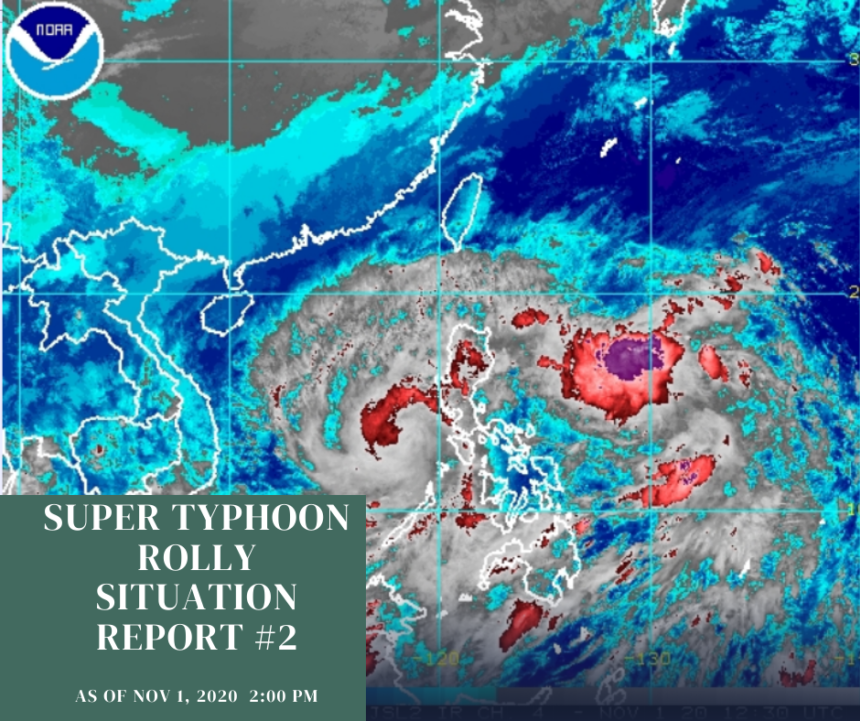
• At 7:20 AM of November 1, Super Typhoon Rolly made a second landfall in the vicinity of Tiwi, Albay., while Tropical cyclone wind signal no.5 is still up over Camarines Sur and Albay and Metro Manila and other parts of the Bicol Region and Southern Luzon are under signal no.4
• As of 8:00 AM, Super TY Rolly weakens into a typhoon and is now off the coast of Pasacao, Camarines Sur.
• As of 10:00 AM, the eye of super typhoon was spotted from Daet Doppler Weather Radar in the vicinity of Tiwi, Albay with maximum sustained winds of 225 kmp/h near the center and gustiness of up to 310 kph while moving west southwest at 25 kph.
• According to PAGASA, a very intense typhoon will affect the locality. Winds greater that 171km/h up to 220 km/h may be expected in at least 12 hours.
• The areas placed under tropical cyclone wind signal no.4: Catanduanes, Camarines Norte, northern portion of Sorsogon (Donsol, Pilar, Castilla, Sorsogon City. Prieto Diaz, Gubat, Barcelona, Juban, Casiguran, Magallanes), Burias Island, central and southern portions of Quezon (Real, Mauban, Perez, Alabat, Quezon, Calauag, Tagkawayan, Guinayangan, San Antonio, Tiaong, Dolores, Candelaria, Sariaya, Tayabas City, Sampaloc, Lucban, Lucena City, Pagbilao, Atimonan, Padre Burgos, Agdangan, Unisan, Plaridel, Gumaca, Lopez, Buenavista, San Narciso, San Andres, San Francisco, Mulanay, Catanauan, General Luna, Macaleon and Pitogo), a central and southern portions of Rizal (Tanay, Antipolo City, San Mateo, Cainta, Taytay, Binangonan, Teresa, morong, Cardona, Baras, Jala-Jala, Pililla and Angono), Batangas, Cavite, Metro Manila, Laguna, Marinduque, northern portion of Romblon (Concepcion, Corcuera, Banton), the northern portion of Occidental Mindoro (Abra de Ilog), northern portion of Oriental Mindoro (Puerto Galera, San Teodor, Baco, Calapan City, Naujan, Pola, Victoria, Socorro and Pinamalayan).
• The areas placed under tropical cyclone wind signal no.3: rest of Sorsogon, northern portion of Masbate, Uson, Baleno, Aroroy, Mandaon) including Ticao Island, rest of Quezon including Polillo Island, rest of Rizal, Bulacan, Pampanga, Bataan, southern portion of Zambales (San Marcelino, San Felipe, Olongapo City, Subic, Castillejos, San Antonio, San Narciso, Botolan and Cabangan), central portion of Romblon (Calatrava, San Andres, San Agustin, Romblon, magdiwang, San Fernando, Cajidiocan), central portion of Occidental Mindoro (Sablayan, Mamburao, Santa Cruz, Paluan including Lubang Island), central portion of Oriental Mindoro (Gloria, Bansud, Bongabong) and Northern Samar.
• The areas placed under tropical cyclone wind signal no.2:Aurora, Benguet,Quirino, Nueva Vizcaya, La Union, Pangasinan, rest of Zambales, Tarlac, Nueva Ecija, rest of Oriental and Occidental Mindoro, rest of Romblon, rest of Masbate, the northern portion of Samar (Catbalogan City, Jiabong, Motiong, Paranas, Hinabangan, San Sebastian, Tarangnan, Pagsanghan, San Jorge, San Jose de Buan, Matuguinao, Gandara, Santa Margarita, Calbayog City, Santo Nino,Almagro, Tagapul-An, northern portion of Eastern Samar (San Julian, Sulat, Taf, Can-Avid, Dolores, Maslog, Oras, San Policarpio, arteche, Jipapad), the extreme northern portion of Antique (Pandan, Libertad, Caluya), and the northwestern portion of Aklan (Buruanga, Malay, Nabas, Ibajay).
• The areas placed under tropical cyclone wind signal no.1: the rest portion of the northern portion of Antique (Sebaste,Culasi,Tibiao, Barbaza, Laua-An), rest of Aklan Capiz, northern portion of Iloilo (Lemery,Sara,Concepcion,San Dionisio, Batad, Estancia, Balasan, Carles), northern portion of Cebu (San Remigio, Bogo City, Medellin, Daanbantayan including Bantayan Islands), Biliran, rest of Samar, rest of Eastern Samar, northern portion of Leyte (San Isidro, Tabango, Villaba, Matag-Ob, Palompon, Ormoc City, Pastrana, Palo, Calubian, Leyte, Kananga, Capoocan, Carigara,Jaro,Tunga, Barugo, Alangalang, Santa Fe, Tacloban City, Babatngon and San Miguel).
• At 12:00 PM, Typhoon Rolly made its third landfall in the vicinity of San Narciso, Quezon ahead of its approach to Metro Manila. TY Rolly further weakens and is now over Mongpong Pass.
• Tropical cyclone warning signal no.5 was lifted after Typhoon Rolly weakened into a typhoon following two landfalls in Bicol Region.
• At 3:00 PM, the eye of the Typhoon Rolly was located based on all available data including these from Daet Doppler Weatger Radar at 50 km Southwest of Tayabas, Quezon with maximum sustained winds of 165 km/h near the center and gustiness of up to 230 km/h and now moving West at 25km/h.
• At 5:00 PM, Typhoon Rolly is heads towards the Southeastern coast of Batangas. Destructive winds and intense rainfall associated with the region of the eyewall and inner rainbands of the typhoon is prevailing or expected within 12 hours iver the Batangas and Cavite. This a particularly dangerous situation for these areas according to PAG-ASA.
• At 5:30 PM, Typhoon Rolly made is fourth landfall in Lobo, Batangas. The typhoon weakened after battering the Bicol region and Quezon province.
• Most provinces, including Metro Manila, have been downgraded to tropical cyclone wind signal no.3 and no more province is placed under tropical cyclone wind signal no.4.
(Source: DOST –PAGASA Severe Weather Bulletin)
Reports on Affected Populations
• As Typhoon batters the country, four deaths have been recorded in Albay. Three were deaths related to an overflowing river when the dike broke and one due to the uprooted trees.
• There were a total of 96,000 families or 346,993 individuals evacuated due to the Typhoon Rolly according to NDRRMC. Majority of which were residents of the Bicol Region with a total of 87,908 evacuees.
• 2,420 families were evacuated in Metro Manila; 88 families in Cordillera Administrative Region; 1,958 families in Central Luzon; 3,266 families in Calabarzon including, 911 families or 18,783 individuals in Quezon and 903 families in Eastern Visayas.
• Schools are being used as emergency shelters as are government-run evacuation centres and gymnasiums. So far, train and flight operations have been suspended to protect passengers from threats due to typhoon.
• Meanwhile, assessment on the cost of damage to infrastructures and agriculture is still ongoing according to NDRRMC.
(Source: NDRRMC / Rappler)
Emergency Response Efforts
• On October 31, CDRC started releasing its Situation Reports.
Resources Available
• Standby emergency funds
• Prepositioned goods at the CDRC warehouse
Expressed Needs
• Immediate needs of the survivors include food, water, clothes, hygiene kits, medicines, masks, and sleeping materials.
Coordination
Regional Center
• Alay-Bayan Luzon (ABI Inc)
• Southern Tagalog People’s Response (STPRC)
• Leyte Center for Development Inc. (LCDE)
• Ilocos Center for Research Empowerment and Development (ICRED)
Contacts
• Sharlene Lopez, Executive Director, (0920-553-4000), info@cdrc-phil.com
• Malen Serato, Field Operations Department, 0916-499-1410, fod@cdrc-phil.com
• Hanna Fiel, Research and Public Information Department, 0945-8355589, hanna.fiel.cdrc2019@gmail.com
• Cora Jazmines, Local Partnerships Department, 0949-845-1271, lpd@cdrc-phil.com

